Immediately northeast of Meadow Court the geological bedrock changes from clay of the Reading Formation (laid down between 66 and 56 million years ago) to the lowest chalk layer, the Portsdown chalk (83.6 to 72.1 million years ago), that lies immediately below it. Before the clay was deposited the chalk had been uplifted and eroded, which explains why all the upper layers of the chalk are missing at this location. Although recorded by the British Geological Survey (BGS) as the bedrock, the chalk is apparently not very close to the surface here, and isn't present in the ploughsoil in this part of the field as would normally be the case on the typically thin soils that develop over chalk. There is chalk in the ploughsoil further across the field and towards the Pains Firework Factory chalkpit.
In addition to these two bedrock strata, the local scene is complicated by the presence of two superficial layers described by BGS as 'Head 1' and 'Head' The lower layer (Head 1) is formed of poorly sorted and poorly stratified sand and gravel, with lenses of silt, clay or peat and organic material been accumulated by hillwash and soil creep in the past 2.588 million years. It covers much of the field behind Meadow Court. The upper layer (Head) is of similar composition, but is only located in the valley bottoms in this area, and here occupies the bottom of the broad valley that runs parallel to the bottom of the gardens. According to the geological map it is centred some 25 metres from the bottom of the new gardens with the closest edge only about 3 metres from the new fence line, but in reality appears to be somewhat further away, perhaps another 35 metres. Although given the same broad date range, it is more recent than the lower layer.
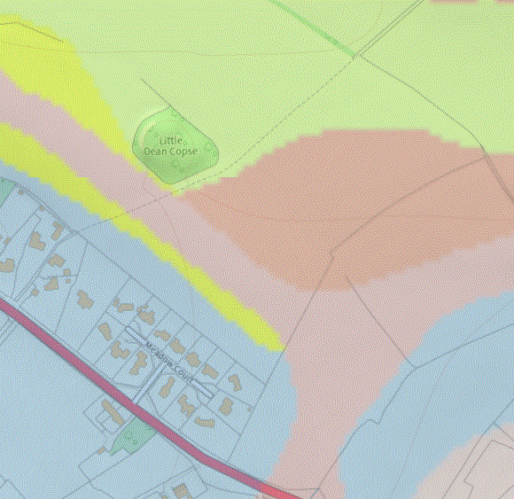
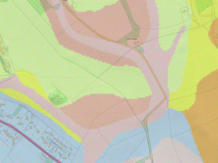
The three maps below show the geology at different scales, with pale blue being the clay of the Reading Formation, yellow being the Portdown Chalk Formation, violet Head 1 and brown Head. On the wider views there is also green representing Culver Chalk, the layer immediately above the Portsdown Chalk, brown for Lambeth Group and a warm brown for London Clay. The Reading Formation is the lowest layer of the Lambeth Group, and London Clay was deposited immediately above the Lambeth Group layers.
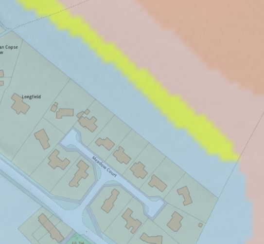
Of particular interest on these maps is the yellow strip showing Portsdown Chalk close to the bottom of the Meadow Court gardens of numbers 4 to 10. As shown on the map, this yellow strip falls within the confines of the March 2024 garden extensions to those houses. A test pit 12 feet (4 metres) from the bottom of these extensions has shown that there is indeed chalk present, but that this is still beneath Reading Formation deposits at a depth of 7 feet (2 metres). It should be recognised that geological maps are interpreted from a wide range of data sources, so small discrepancies in the position of boundaries are very much to be expected.
Blue: Reading Formation, Yellow: Portsdown Chalk Formation, Pale brown: Head, Dark brown: Head 1
Centre: Green: Culver Chalk Formation, Grey: London Clay Formation at bottom right corner
Right: additional colour Brown: Lambeth Group
Contains British Geological Survey materials ©NERC 2024
Online Resources
The source maps for these examples come from two readily accessible BGS online tools, as follows:
BGS Geology Viewer, this viewer accepts a postcode, but the more detailed tool below doesn't.
BGS Geo Index, a more detailed resource, although a little more complex to use. In particular it is necessary to select 'Add Layers' to add the layers to be displayed. A useful trick is to select both 625,000 and 50,000 layers so that something is displayed at all scales. Nothing will be displayed if the scale selected is too large or too small. [Technical point: this link only works with the / missed off the end of the address, as in the above hyperlink.]
Geological cross section north through Whiteparish
Dean Hill is an upward ripple in the local chalk bedrock, laid down between 100 and 61 million years ago. It used to be thought that this formed during the Alpine Orogeny, but more recently is considered to be the result of the relative movement of a series of earlier (Variscan, 380-280 million years ago) faults in the underlying strata, where later compression caused further upward and downward movement of the underlying blocks, folding the more plastic later layers over the surface. The top surface of this ripple has been eroded, leaving successively older layers exposed as you walk up Dean Hill from Whiteparish, and then successively younger layers descending the hill to West Dean on the other side. The chalk surface was exposed for some 6 million years before the younger rocks were deposited, so the layers of clay, silt and gravel that form the Lambeth Formation and London Clay lie unconformably on an eroded chalk surface. Whiteparish sits astride the London Clay, Lambeth Formation and just onto the edge of the chalk to the north.
The diagram below shows the geological strata below the ground and at the surface in a north-south cross section through Whiteparish. The left hand side starts on the London Clay of Clay Street, passes through the centre of Whiteparish (marked with a red pin), over Dean Hill and across the river Dun a little to the west of West Dean. It finishes back on the London Clay. A section through Meadow Court would look almost identical. As a result of the fold the geological beds under Whiteparish are exposed in the opposite order on the far side of Dean Hill. The eroded strata are shown by red lines above the ground surface to indicate how the fold was originally. This fold in the strata is known as the Dean Hill Anticline (for a definition of anticline, see anticline ).
At the top of the diagram is a strip from the geological map and below it the profile of the ground surface over a geological cross section, with height exaggerated by 11.5 times for clarity. Below this is the real profile of the ground using the same scale for vertical and horizontal axes. For clarity I've used the same cyan (blue) for the Reading Formation south of Dean Hill and the Lambeth Group exposure to the north. The Reading Formation is part of the Lambeth Group, so this is essentially the same layer. The Reading Formation is sand in the center of the village (e.g. The Triangle), but is also shown on the map as sand under Meadow Court, where it is most emphatically clay. Ideally the geological map should show Reading Formation clay or Lambeth Group clay here: Lambeth Group is shown further along the A27 at Cowesfield Green and in the outcrop north of Dean Hill.
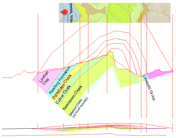
A north-south section through the centre of Whiteparish, showing 11.5:1 height exaggeration, with 1:1 section below
See explanation of diagram above
The section of map at the top contains British Geological Survey materials ©NERC 2024
All the houses and gardens in Meadow Court are on the Reading Formation, with the Portsdown Chalk immediately to the north in the field. On the geological map the bottom of the 2024 extension of the gardens on the north side of Meadow Court reach the middle of this narrow strip of chalk bedrock at the surface. Beyond that are two layers of more recent 'Head' accumulations on top further into the field, but even where shown as outcropping close to Meadow Court the chalk is deep enough below the surface not to have been reached by ploughing. The earlier layer of head covers the near half of the field beyond the gardens, with the later layer of head forming a narrow strip on top of it along the valley bottom.
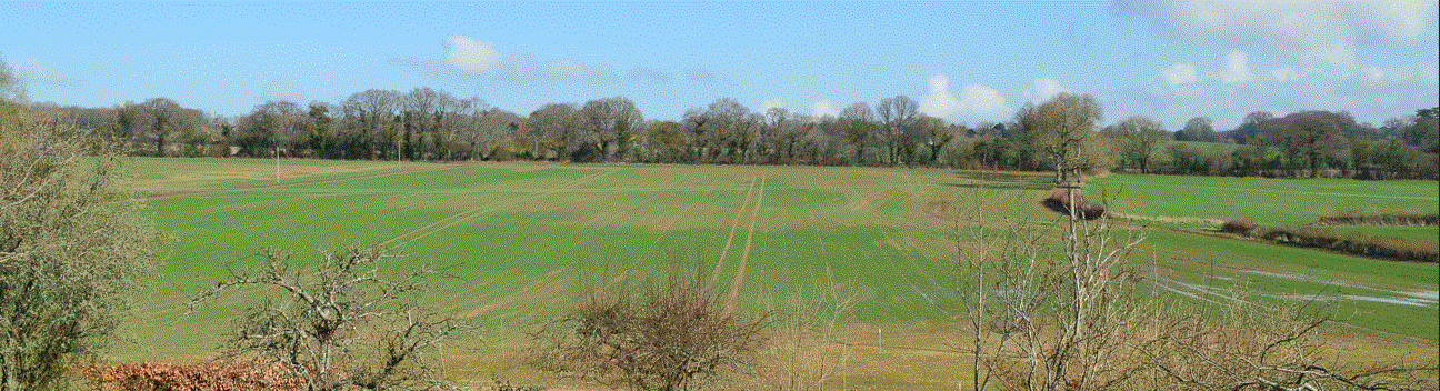
The extent of the lower layer of head, referred to on the map as Head 1, is very much in evidence in the early spring development of crops on the field, showing up as more luxuriant growth than on the chalk subsoil at the top of the field. The later Head in the valley bottom is also visible, although less obvious, in this photograph, showing up as a slightly less vigorous growth in the foreground along the valley bottom, which is picked out by the lying water extending from the right hand side of the picture. The very poor growth nearer the camera, where the marker posts are for the garden extensions, is a result of this year's cultivation pattern, rather than of geological origin. Comparison of these areas with the geological map at the top right of this page show how the geological cartographers have needed to approximate the edge of this formation, something that also appears to be at work in the chalk indicated at the bottom edge of the garden extensions.
.gif)
The field in March 2024, showing richer growth of winter wheat over the area where Head 1 is at the surface
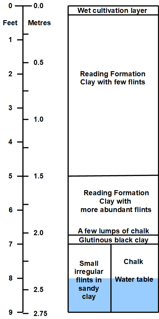
Geology test pit in new garden area
Over the weekend of 23rd to 26th February 2024 a test pit was dug on the centre line of one garden 4 metres from the line to be taken by the new bottom fence. This was stepped down and progressively widened from the top to enable digging to reach a full depth of 9 feet (2.75 metres) to investigate the geology and prove or disprove the presence of the chalk surface. The deepest part of the base of this hole is roughly a metre long by half a metre wide at the 7 foot level. A very hard and solid chalk surface was reached at one end of the lowest layer of the hole at a depth of 7 feet (2.1 metres), but small irregular flints in a more sandy matrix continued down at the other end of the base of the hole for a further 2 feet without reaching chalk. The water table was reached at a depth of 8 feet / 2.4 metres and digging stopped underwater at 9 feet / 2.75 metres. The walls of the hole proved extremely stable, but an additional safely margin was added by stepping the sides to provide enough working space at shoulder height and to provide necessary steps for getting in and out of the hole. No weakness or collapse of material has been observed in the following two weeks despite considerable quantities of rain that continued a trend of very wet weather throughout 2023 and the recent winter.
The layers encountered were as follows:
- Top 2 inches: very wet and plastic clay
- Down to 5 feet: uniform slightly sandy clay (Reading Formation) with occasional medium sized flints. Orange-brown, becoming slowly more yellow with depth. Slightly damp, but basically crumbly for the most part, with occasional small lenses of more glutinous clay.
- From 5 feet to 7 feet: A slightly sandier clay with large numbers of small irregular flints
- At 7 feet: a 2 inch layer of very glutinous black clay immediately above solid chalk at one end of the hole and further flints at the other. The chalk surface found is knobbly with a 2 inch structure of grooves and very hard with no signs of weakness or erosion. Determined impact of a spade left no marks and broke no pieces off. However in the 6 inches or so above the black clay layer there were a number of irregular pieces of hard broken chalk typically cuboid with a maximum dimension of perhaps 3 inches.
- From 7 to 9 feet: small irregular flints in a sandy matrix (still with some clay content)
- At 8 feet: the water table, which rose slightly (a few centimetres) after breaking through into it.
Section through the geology 70 metres northeast of Meadow Court
In seven shallow (18 inch deep) test pits distributed up the full length of the centre line of the 35 metre new garden extension, rain water collected overnight and showed no sign of soaking away over four days. This is consistent throughout the full 38.5 metre length of the existing garden and the 35 metres of the new extension, although sub-spherical ironstone nodules 3 to 4 inches across were found in a 5x5x5 foot pit dug close to the back door as a soakaway in 2003 or so. Neither that soakaway nor one in the front garden immediately south of the front corner of the house showed any sign of water soaking away, and a pit nearby in the south corner retained water for several weeks through hot summer weather without obvious signs of the level reducing. It did dry out after several months.
Other local geology resources
This website has various other pages covering aspects of local geology, as listed below. At the time of writing (26.2.2024) these links have not yet been uploaded for public viewing. Most are ready to release, so please do ask if you would like to see a particular page. Magenta links are copyright material, so cannot be made available on my website - direct links are given where available.
- Whiteparish Geology
- Geology - an early version of the page on Whiteparish Geology above, still with material not covered elsewhere
- Solent River Geology Quaternary history of the Solent from 12,000 years ago to the present (SCOPEC copyright, only available directly: SCOPEC)
- Solent River Geology Analysis analysis of the above paper in note form (bullet list)
- Cretaceous chalk formations from Whiteparish village to Dean Hill
- Palaeogene clay/sand/silt formations from Whiteparish to the coast
- Geology introduction a guide to all geological Periods, Eras and Eons from the present Quaternary Period to the earliest Hadean Eon, plus timeline of life
Basement block faults under the chalk
It was originally thought that folds in the chalk such as the Dean Hill Anticline and the Wealden Dome were the result of northward compression during the Alpine Orogeny. By 1982 the British Regional Geology was suggesting that a different mechanism was responsible, that the chalk and later layers were draped over a series of block faults, and that movement of these was responsible for the surface structure. These upper layers being more pliable, they have folded rather than faulted above these basement faults. According to this theory the last movement along these faults was a downthrow to the north, resulting in the asymmetrical structure with the scarp slope facing north towards West Dean and the shallower dip slope facing Whiteparish. Slippage along faults trending northwest-southeast is postulated to have caused the relatively short length of features like the Dean Hill anticline, truncating the ridge close to Salisbury and the East Dean/Lockerly area. The Dun valley lies along the line of a syncline north of the Dean Hill anticline. (Anticline = upward fold, syncline = downward fold.)
In the diagram below, note that the label 'Dean Hill Anticline' refers to the black feature at the end of a black arrow somewhat to the north of the label itself, lying between a red upthrow fault to the south and red downthrow fault to the south, and not to the red fault close to the label.
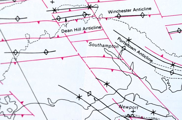
Postulated basement block faults underlying the chalk related to surface features
British Regional Geology, Hampshire Basin and adjoining areas, 4th edition, Crown Copyright 1982, HMSO
See this article for a detailed more recent description from the British Geological Survey, dated 2003 [Booth, K A. 2002. Geology of the Winchester district — a brief explanation of the geological map. Sheet Explanation of the British Geological Survey. 1:50 000 Sheet 299 Winchester (England and Wales). Keyworth, Nottingham: British Geological Survey].